A Sunburnt Country
Note to Yarns from the Farm readers: This is the final regular article in a series on climate change that I’m writing for our local monthly newsletter, the Southern Midlands Regional News (SMRN). There will be a recap article in the next issue, that reviews the whole series. Previous articles can be found in the preceding Yarns from the Farm. The image above was taken after a major fire went through my property in January 2016. And a note to my non-Australian readership: this title and the previous one are taken from a much-loved poem, My Country, written by Australian Dorothea Mackellar at the age of 19, at the turn of the last century.
It is with some trepidation that I put pen to paper to write about bushfire risk forecasting. Although I am not at all superstitious, in the two months since I began writing about runoff and flooding, we’ve had four significant recharge events and the landscape is decidedly soggy for the first time in about five years! So, I’m wary of the possible consequences of writing about bushfire risk at this juncture, especially given the likelihood of high fuel loads after all this lovely rain.
We know from Graham Green’s articles in SMRN on adapting to climate change that fire danger for the midlands over the coming decades is forecast to increase.
Those long-range forecasts involve two major components: large-scale models of the climate system, coupled with dynamical estimates of relevant local variables like temperature, rainfall, soil dryness, etc.
In this article I’d like to dig into how those “relevant local variables” are estimated, as a way of exploring how reliable the long-range climate change forecasts might be.
The risk of bushfire depends critically on the fuel dryness level. Fuel dryness can be measured quite accurately, by drying actual samples of fuel in a calibrated drying oven for 24 to 48 hours, at a temperature between 80 and 105 C, and measuring the amount of moisture released. (Overall, 80°C for 48 hours is recommended given the risk of setting the drying oven on fire at higher temperatures.)
However, by the time you have taken that measurement, it’s too late to use in an operational forecast system. Instead, a “derived” variable, the Forest Fire Danger Index (FFDI) is constructed from several more easily-observed variables, like temperature, humidity, runoff and rainfall history.
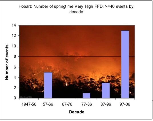
The figure is from R. M. B. Harris, T. Remenyi, P. Fox-Hughes, P. Love, H. E. Phillips, N. L. Bindoff 2017: An assessment of the viability of prescribed burning as a management tool under a changing climate: a Tasmanian case study. Peer reviewed research proceedings from the Bushfire and Natural Hazards CRC & AFAC conference Sydney, 4 – 6 September 2017.
The hope is that FFDI will mimic the fuel load dryness with useful accuracy. It’s possible to check that accuracy by comparing past forecasts of FFDI with the measured fuel dryness data where it’s available. Those comparisons allow the calculation of FFDI to be fine-tuned and improved over time.
Two other derived variables, soil dryness index and drought factor, go into making up the FFDI. The soil dryness index estimates the amount of rainfall required to saturate the soil profile. The Drought Factor estimates the proportion of surface fuel that is dry enough to burn, and varies between 0 (all of the surface fuel is too wet to burn) and 10 (all of the surface fuel is dry enough to burn)*.
Our current soil dryness index is zero, as the soil is saturated. Our current drought factor is presumably close to zero as well, given the generally soggy conditions. So our Forest Fire Danger Index should be very low.
Because the soil dryness index is cumulative (i.e. rainfall effects on soil moisture accumulate over time) the inherent uncertainties in the estimate also accumulate, making it less reliable the longer we go without a soil saturation event to reset the index to zero. The good news is we’ll start this fire season with a solid reset and hence the best accuracy we can get.
Despite the complexity and uncertainty, it’s certainly worth trying to forecast changes in bushfire risk with increasing global temperatures, though, as with all forecasts, the index needs to be constantly tested and refined.
And, knock on wood, our low soil dryness index and drought factor will carry us safely through summer without any extreme bushfire events!
*Reference: Marsden-Smedley JB 2009. Planned burning in Tasmania: operational guidelines and review of current knowledge. Fire Management Section, Parks and Wildlife Service, Department of Primary Industries, Parks, Water and the Environment, Hobart, Tasmania.